Site Selection
The selection of a site to carry out the stream-dwelling salamander survey is very important, as this site will be surveyed indefinitely for years to come to monitor the status of Ohio's salamanders. Selected sites for monitoring should be located within a protected area, such as a preserve, park, or forest. Stream-dwelling salamanders do not occur in northwestern Ohio (Fig. 1), therefore, sites should not be located in this part of the state.
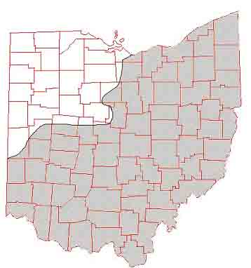
Figure 1. Areas inhabited by stream-dwelling salamanders (shaded).
In general, the most productive sites for surveying and monitoring Ohio's stream-dwelling salamanders will be in small headwater or primary headwater streams. A headwater stream is defined as a stream with a drainage area of less than 20 mi2. Primary headwater streams are those streams with a drainage area of less than 1 mi2. In these habitats salamanders often replace fish as the top vertebrate predators. While chub, dace, and sculpin typical of headwater streams may be present in the selected site, you should avoid areas containing predaceous fish such as sunfish or bass. Selected sites may be intermittent streams (those that do not flow year-round), however, during non-drought years the site should maintain some pools of water at all times. Coldwater habitats, such as spring-fed streams, usually have the greatest salamander species richness.
The best method for locating sites for the survey is to consult your county's soil maps. These are usually available free of charge from the USDA's Soil and Water Conservation District Office in your county or from the local library. USGS topographical maps often do not show the small headwater streams, but these waterways are usually visible on the soil maps. Consultation with naturalists, local biology professors, and the EPA's office that serves your region may aid you in locating streams that fit the above criteria. If you should have any questions concerning the suitability of a particular site as a monitoring station, contact the survey coordinator .
Once a site has been selected, you will need to select a 60-meter segment of the stream to be used for salamander monitoring. The segment selected should be representative of the habitats found within the stream, and should include pools, riffles, and runs. Areas containing cobble substrate (rocks of 64 to 128 mm length) are often the best areas for surveying salamanders. Permanent marking of the stream segment is preferred (a piece of rebar placed in the ground at the beginning and end of the stream), but at the very least, mark the segment with surveyor's tape or flags.
Site Description
Prior to beginning your survey, you will need to fill out the data sheet titled "Site Description." Instructions for completing the Site Description form are included, and directions for measuring the average bankfull width of the site are given below. Fill in the appropriate information concerning the site, including a rough sketch of the site to be monitored. The Site Description only needs to be completed once, and the surveyors should make a copy of the sheet for their own records prior to mailing the original form to the survey coordinator.
Measuring Bankfull Width
The bankfull width is a geomorphological measurement of the site that has been defined as “…the discharge at which channel maintenance is the most effective”(Dunne and Leopold 1978). To measure the bankfull width, mark the boundary line where terrestrial vegetation begins along the stream margin. The line may also be definable by the presence of stained rocks and/or the presence of exposed root hairs below an intact soil layer (Rosgen 1996). The bankfull width is the distance measurement between these two lines on either side of the stream segment. Note that the bankfull width measurement will be somewhere between the width of the stream channel and the width of the floodplain (Fig. 2).
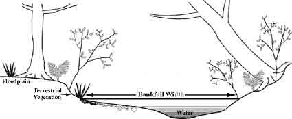
Figure 2. The bankfull width is an important attribute of the stream.
Often it will be possible to determine the bankfull stage on only one bank of the stream. Therefore, once there is confidence in one bankfull boundary, use the following procedure to determine the bankfull width:
1. Tie a string to a surveyor's flag and stake it at the known bankfull stage on one side of the stream.
2. Place a bubble-type line level on the measuring string.
3. Suspend the measuring string perpendicular to the stream flow from the staked location to the opposite bank.
4. Pull string taunt and manipulate up and down until the line level indicates that the string is level.
5. Mark the location where the string intersects the opposite bank.
6. Measure the distance between the marked bankfull locations on either bank of the stream.
The bankfull width should be measured at 3 relatively straight segments of the site, preferably in riffle sections (or glide/run if no riffle sections in the site). Circle the appropriate choice on the Site Description form for the average of these three measurements.
Next section: Mesh leaf bags